Uruapan International Airport
Uruapan International Airport Aeropuerto Internacional de Uruapan | |||||||||||
|---|---|---|---|---|---|---|---|---|---|---|---|
 | |||||||||||
| Summary | |||||||||||
| Airport type | Public | ||||||||||
| Operator | Olmeca-Maya-Mexica | ||||||||||
| Serves | Uruapan, Michoacán, Mexico | ||||||||||
| Time zone | CST (UTC−06:00) | ||||||||||
| Elevation AMSL | 1,603 m / 5,259 ft | ||||||||||
| Coordinates | 19°23′48″N 102°02′21″W / 19.39667°N 102.03917°W | ||||||||||
| Website | www.grupomundomaya.com/UPN | ||||||||||
| Map | |||||||||||
  UPN Location of airport in Michoacán  UPN UPN (Mexico) | |||||||||||
| Runways | |||||||||||
| |||||||||||
| Statistics (2025) | |||||||||||
| |||||||||||
| Source: Agencia Federal de Aviación Civil[1] | |||||||||||
Uruapan International Airport (Spanish: Aeropuerto Internacional de Uruapan); officially Aeropuerto Internacional Lic. y Gen. Ignacio López Rayón (Lic. y Gen. Ignacio López Rayón International Airport) (IATA: UPN, ICAO: MMPN) is an international airport located in Uruapan, Michoacán, Mexico. It serves domestic and international flights and it supports flight training, executive aviation, and general aviation activities. Operated by Grupo Olmeca-Maya-Mexica (GAFSACOMM), a federal government-owned corporation, the airport is named after Ignacio López Rayón, a leader in the Mexican War of Independence. The airport served 172,193 passengers in 2024, a figure which increased slightly to 175,010 in 2025.[1]
History

The first air services to Uruapan began in 1937, connecting the city to Acapulco. The airport joined the Aeropuertos y Servicios Auxiliares (ASA) network in 1970. Regional airlines Aero Cuahonte and Aero Sudpacífico were once based here. Over the years, Uruapan Airport has been served by various airlines, including Aeromar, Avolar, Líneas Aéreas Azteca, and TAESA Airlines.[2] Volaris launched the airport's first international service to Los Angeles in October 2012.[3] In 2023, airport operations shifted to Grupo Olmeca Maya Mexica (GAFSACOMM), a military-owned entity, aligning with the López Obrador administration's strategy to involve the armed forces in major infrastructure projects.
Facilities
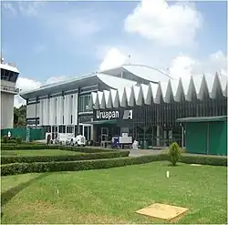
The airport is situated within the Uruapan urban area, covering an approximate area of 264 hectares (650 acres), at an elevation of 1,603 metres (5,259 ft) above sea level. It features a 2,400 metres (7,900 ft) asphalt runway, capable of accommodating aircraft like the Boeing 737 and Airbus A320. The commercial aviation apron spans 15,652 square metres (168,480 sq ft) and can accommodate three narrow-body aircraft. The airport operates daily from 07:00 to 19:00.
The passenger terminal, a two-story structure, accommodates arrivals and departures, offering standard services commonly found at regional airports. These services include parking facilities, a check-in area, a security checkpoint, a VIP lounge, retail outlets, immigration and customs facilities, baggage claim zones, an arrivals hall with car rental services and taxi stands, and a departure concourse with three gates providing direct access to the apron. With no jet bridges, passengers walk to their aircraft. The airport also houses logistics and courier companies, administrative, and police facilities.
Airlines and destinations
Passenger
| Airlines | Destinations |
|---|---|
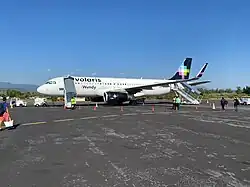
| Volaris | Los Angeles,[4] Tijuana[5] |
Destination maps
Domestic destinations from Uruapan International Airport Red = Year-round destination Blue = Future destination Green = Seasonal destination |
International destinations from Uruapan International Airport Red = Year-round destination Blue = Future destination Green = Seasonal destination |


Statistics
Annual Traffic
| Year | Total Passengers | change % | Cargo movements (t) | Air operations |
|---|---|---|---|---|
| 2006 | 150,047 |  |
251 | 7,569 |
| 2007 | 135,211 |  9.89% 9.89% |
221 | 6,869 |
| 2008 | 110,816 | 18.04% |
71 | 7,417 |
| 2009 | 106,748 | 3.67% |
9 | 7,159 |
| 2010 | 107,379 |  0.59% 0.59% |
11 | 6,481 |
| 2011 | 109,455 | 1.93% |
1 | 6,312 |
| 2012 | 112,275 | 2.58% |
11 | 5,509 |
| 2013 | 113,101 | 0.74% |
40 | 5,074 |
| 2014 | 106,949 | 5.44% |
28 | 4,866 |
| 2015 | 110,067 | 2.92% |
1 | 4,816 |
| 2016 | 128,578 | 16.82% |
0 | 4,145 |
| 2017 | 150,192 | 16.81% |
0 | 4,485 |
| 2018 | 160,045 | 6.6% |
- | 5,201 |
| 2019 | 167,796 | 4.84% |
0 | 5,123 |
| 2020 | 129,019 | 23.11% |
0 | 4,238 |
| 2021 | 167,112 | 29.53% |
0 | 5,032 |
| 2022 | 151,151 | 9.55% |
0 | 4,599 |
| 2023 | 173,005 | 14.46% |
0 | 4,546 |
| 2024 | 172,193 | 0.47% |
0 | 4,819 |
| 2025 | 175,010 | 1.64% |
0 | 4,992 |
Accidents and incidents
- TAESA Flight 725, a DC-9, crashed on take-off from Uruapan International Airport en route to Mexico City on November 25, 1999, killing all 18 people on board.[6]
See also
- List of the busiest airports in Mexico
- List of busiest airports in North America
- List of the busiest airports in Latin America
- List of airports in Mexico
- List of airports by ICAO code: M
- Airline destinations: Mexico
- Aero Sudpacífico
- Transportation in Mexico
- Tourism in Mexico
References
- ^ a b c "Estadística Operacional de Aeropuertos / Statistics by Airport". Agencia Federal de Aviación Civil. Retrieved January 30, 2026.
- ^ "Líneas Aéreas Azteca". AerolineasMexicanas.com.mx. Retrieved March 6, 2021.
- ^ "Volaris to Fly From Uruapan to Los Angeles". Routes Online. August 2012. Retrieved March 6, 2021.
- ^ Mutzabaugh, Ben. "Los Angeles to Acapulco, non-stop on Volaris". USA TODAY. Retrieved January 22, 2026.
- ^ Olivares, Leia (February 9, 2024). "Muere pasajera de Volaris; aterrizaron de emergencia en Culiacán". Periódico Correo (in Mexican Spanish). Retrieved January 22, 2026.
- ^ "Accident description". Aviation Safety. November 1999. Retrieved August 15, 2017.
External links
 Media related to Uruapan International Airport at Wikimedia Commons
- Official Website
- Grupo Olmeca Maya Mexica
- Aeronautical chart and airport information for MMPN at SkyVector
- Current weather for MMPN at NOAA/NWS
- Uruapan Airport information at Great Circle Mapper
- Accident history for URU at Aviation Safety Network