Highway 42 (Thailand)
 | |
|---|---|
| ทางหลวงแผ่นดินหมายเลข 42 | |
| ถนนเพชรเกษมปัตตานี-นราธิวาส, ถนนเกาหลี (บาตะห์ กอลี), ถนนรามโกมุท Phetkasem of Pattani-Narathiwat Road, Korean Road (Batah Koli), Ramkomut Road | |
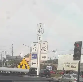 Highway 42 in Don Yang Intersection, Nong Chik District, Pattani Province | |
| Route information | |
Part of  AH18 AH18 | |
| Length | 262.312 km (162.993 mi) |
| Existed | 1950–present |
| Major junctions | |
| West end |  Hwy 4 Hwy 4  AH2 in Sadao (Songkhla Province) AH2 in Sadao (Songkhla Province) |
 Hwy 408 Hwy 408 Hwy 409 Hwy 409 Hwy 43 / AH18 Hwy 43 / AH18   Hwy 418 / Hwy 4296 / Hwy 4354 Hwy 418 / Hwy 4296 / Hwy 4354 Hwy 410 Hwy 43 Hwy 410 Hwy 43  Hwy 4359 Hwy 4359 | |
| East end |   FT 3 / AH18 in Su-ngai Kolok (Narathiwat Province) FT 3 / AH18 in Su-ngai Kolok (Narathiwat Province) |
| Location | |
| Country | Thailand |
| Provinces | Songkhla, Pattani, Narathiwat |
| Major cities | Pattani, Narathiwat, Su-ngai Kolok |
| Highway system | |
Route 42 (Thai: ทางหลวงแผ่นดินหมายเลข 42) as known Khlong Ngae - Su-ngai Kolok Highway or Phetkasem Road of Pattani-Narathiwat[1] in time when traveling from Pattani to Narathiwat. or Korean Road[2] or Batah Koli in northeastern Malay language[3] is a southeastern highway that connects Songkhla Province, Pattani Province and Narathiwat Province. There is a distance throughout the line of 263.779 kilometers.
History
Before highway numbers were assigned The road in the Pattani-Narathiwat section is called Pattani–Narathiwat Highway Later it was named Ramkomut Road on December 10, 1950, when Field Marshal P. Pibulsongkram was Prime Minister. In honor of Luang Parinya Yokhawibun (Chom-Ubon Ramkomut), the master technician who supervised the construction.[4]
South Korean company, Hyundai Engineering & Construction (Including the former president of South Korea, Lee Myung Bak) also involved in the construction of Pattani (Don Rak)-Narathiwat highway section as supervisors in 1965, which is now locals called Korean Road.[2]
In the past, Highway 42 usually routed from Ban Khlong Ngae, Sadao District , Songkhla Province to Ban Don Yang, Nong Chik District , Pattani Province. It is the main route for traveling between Songkhla Province and Pattani Province. But when there is construction of Highway 43 has increased, causing vehicles traveling to use this route instead. Because it helps to reduce time and distance better. It is also a 4-lane highway, while Highway 42, Khlong Ngae - Don Yang section. It is a 2 lane highway.
Highway 42 used to end in the city of Narathiwat. The distance at that time was approximately 198 kilometers (123 miles). Later, Highway 4084 and Highway 4057 were included as part of this highway as well. To connect to the border crossing point at Su-ngai Kolok.
Junction and town lists
Legend:
- I/C - Interchange, I/S - Intersection, RSA - Rest and service area, OBR - Overhead bridge restaurant, R/R - Restaurant and rest plaza, L/B - Layby, V/P - Vista point, TN - tunnel, T/P - Toll plaza, BR - Bridge
| Province | District | Km | Exit | Name | Destinations | Notes |
|---|---|---|---|---|---|---|
 Songkhla Songkhla
|
Sadao | 0+000 | Sadao | Hwy 4 / AH2 – Bangkok, Songkhla, Hatyai, Dannok, Padang Besar
|
T-junctions | |
| Phangla | SK.2039 – Hatyai | T-junctions | ||||
| Na Thawi | 29+183 29+693 |
Na-Thawi | Hwy 408 – Hatyai, Songkhla, Ban Prakob
|
Junctions | ||
| Wang Yai | SK.2032 – Nathawi SK.2003 – Sathon |
T-junctions | ||||
| Thepha | 60+132 | Thepha |  Hwy 4085 – Chana, Ban Phraphut, Sabayoi, Kabang, Yala Hwy 4085 – Chana, Ban Phraphut, Sabayoi, Kabang, Yala
|
Junctions | ||
| Songkhla-Pattani provincial border | BR | Thayee Bridge | ||||
 Pattani Pattani
|
Khok Pho | Khok Pho train crossing | ||||
| Khok-Pho | PN.2003 – Nong Chik PN.2063 – Chang Hai Tok |
Junctions | ||||
| 82+600 | Naket | PN.2010 – Ban Basa-ae, Yarang Hwy 409 – Ban Niang, Yala, Yaha
|
Junctions | |||
| Khok Pho-Nong Chik border | BR | Bo Thong Bridge | ||||
| Nong Chik | 89+600 | Bang Khao (Don Yang) | Hwy 43 / AH18 – Bangkok, Songkhla, Hatyai, Thepha, Yarang, Yaring, Narathiwat
|
Junctions | ||
| BR | Bang Khao Bridge | |||||
| Nong-Chik | PN.2070 – Ban Prang PN.2013 – Yarang |
T-junctions | ||||
| Mueang Pattani | 100+236 | Rusamilae (Don Rak) | Hwy 4296/ Hwy 4354 – Mueang Pattani Hwy 418 – Maelan, Ban Limud, Yala
|
Junctions | ||
| Pattani River Bridge | ||||||
| 103+658 | Pattani, Thailand | Yarang Road – Mueang Pattani, Anoru Hwy 410 – Yarang, Yala, Betong
|
Junctions (under construction of new bridge) | |||
| 107+900 | Bana |  Hwy 4356 – Mueang Pattani, Pattani Port Hwy 4356 – Mueang Pattani, Pattani Port Hwy 4355 – Mueang Pattani Hwy 4355 – Mueang Pattani
|
T-junctions | |||
| Tanyong Lulo |  Hwy 4357 – Masjid Krue-Se, Bang Pu Hwy 4357 – Masjid Krue-Se, Bang Pu
|
Y-junction | ||||
| Barahom |  Hwy 4297 – Bangpu, Yaring, Yamu Hwy 4297 – Bangpu, Yaring, Yamu
|
T-junctions | ||||
| Buecho |  Hwy 4358 – Yaring Hwy 4358 – Yaring
|
T-junctions | ||||
| Yaring | 112+800 | Ban Dee | Hwy 43 – Yarang, Nongchik, Hatyai, Songkhla
|
T-junctions | ||
| 11X.XXX | Bang Pu | Hwy 4359 – Yaring
|
T-junctions | |||
| 1XX+XXX | Yaring | Local Highway – Talok Kapor PN.2020 – Mayo, Yarang |
||||
| 12X+XX | Yamu |  Hwy 4298 – Yaring Hwy 4298 – Yaring
|
Junctions | |||
| BR | Khlong Tanyong Bridge | |||||
| 126+208 | Tanyong Dalo |  Hwy 4075 – Ban Nok, Panare Hwy 4075 – Ban Nok, Panare
|
T-junctions | |||
| Mayo-Panare | 135+108 | Mayo/Panare |  Hwy 4061 – Panare, Mayo, Thungyangdaeng, Yarang, Yala Hwy 4061 – Panare, Mayo, Thungyangdaeng, Yarang, Yala
|
Junctions | ||
| Sai Buri | 145+325 | Trobon | PN.2061 – Ban Chamao Samton, Saiburi Hwy 4074 – Thungyangdaeng, Raman, Yala Hwy 4074 – Thungyangdaeng, Raman, Yala
|
Junctions | ||
| 14X+XX | Cho-kueyae |  Hwy 4299 – Saiburi, Yaring, Raman Hwy 4299 – Saiburi, Yaring, Raman
|
Junctions | |||
| BR | Saiburi River Bridge | |||||
| 152+866 | Saiburi |  Hwy 4060 – Taluban, Saiburi, Kapho, Raman, Si Sakhon Hwy 4060 – Taluban, Saiburi, Kapho, Raman, Si Sakhon
|
Junctions | |||
| 154+559 | Lahan |  Hwy 4157 – Saiburi, Panare, Ban Talokapo Hwy 4157 – Saiburi, Panare, Ban Talokapo
|
T-junctions | |||
| Pattani-Narathiwat provincial border | BR | Kodo Bridge | ||||
 Narathiwat Narathiwat
|
Bacho | 159+042 | Ban Kodo |  Hwy 4136 – Maikaen, Mueang Narathiwat Hwy 4136 – Maikaen, Mueang Narathiwat
|
T-junctions | |
| 160+461 | Palukasamo |  Hwy 4168 – Kapho, Raman, Yala, Maikaen, Bacho, Mueang Narathiwat Hwy 4168 – Kapho, Raman, Yala, Maikaen, Bacho, Mueang Narathiwat
|
Junctions | |||
| 171+196 | Bacho | Local Highway – Pataerayo Waterfall, Raman Hwy 4155 – Mueang Narathiwat Hwy 4155 – Mueang Narathiwat
|
Junctions | |||
| Yi-ngo | 180+096 | Tapoyo |  Hwy 4066 – Rueso, Raman, Yala, Mueang Narathiwat Hwy 4066 – Rueso, Raman, Yala, Mueang Narathiwat
|
Junctions | ||
| Yi-ngo |  Hwy 4300 – Ra-ngae, Rueso, Si Sakhon Hwy 4300 – Ra-ngae, Rueso, Si Sakhon
|
Y-junctions | ||||
| Mueang Narathiwat | 193+536 | Narathiwat |  Hwy 4084 – Bang Nak, Takbai Hwy 4084 – Bang Nak, Takbai
|
T-junctions | ||
| 197+333 | Lamphu |  Hwy 4055 – Mueang Narathiwat, Ra-ngae, Ban Dusongnyo, Chanae Hwy 4055 – Mueang Narathiwat, Ra-ngae, Ban Dusongnyo, Chanae
|
Junctions | |||
| BR | Bang Nara Bridge | |||||
| 211+988 | Sapom | Hwy 4084 – Mueang Narathiwat, Yi-ngo
|
Junctions | |||
| Tak Bai | 229+962 | Tak-Bai |  Hwy 4237 – Chehe Hwy 4237 – Chehe
|
T-junctions | ||
| BR | Chehe Bridge | |||||
| Su-ngai Kolok | 262+283 | Pasemat | NT.4031 – Su-ngai Padi | T-junctions | ||
| Su-ngai Kolok train crossing | ||||||
| 262+929 | Su-ngai Kolok |  Hwy 4056 – Su-ngai Padi, Cho-airong, Mueang Narathiwat Hwy 4056 – Su-ngai Padi, Cho-airong, Mueang Narathiwat Hwy 4057 – Waeng, Buketa, Lochut, Sukhirin Hwy 4057 – Waeng, Buketa, Lochut, Sukhirin
|
Junctions | |||
| Su-ngai Kolok Checkpoint | ||||||
| 263+779 | BR | Kolok River Bridge | Crossing Length: 109.73 m | |||
| ASEAN Thailand–Malaysia Border Through to FT 3 / AH18 Malaysia Federal Route 3
| ||||||
References
- ^ "แผนที่ทางหลวงในความควบคุมของสำนักทางหลวงที่ 15 (สงขลา)". Archived from the original on 2016-03-05.
- ^ a b วลัยลักษณ์ ทรงศิริ. ""ปาตานี" นครแห่งความทรงจำ". มูลนิธิเล็ก-ประไพ วิริยะพันธุ์. Archived from the original on August 6, 2014.
- ^ Najib Bib Ahmad. "ถนนเกาหลี". มูลนิธิเล็ก-ประไพ วิริยะพันธุ์. Archived from the original on June 5, 2022.
- ^ "ประวัติที่มาของชื่อ ถนนทางหลวง ต่างๆ". Archived from the original on 2017-08-19. Retrieved 2024-04-04.


Sources
- ระบบสารสนเทศโครงข่ายทางหลวง Archived 2016-06-16 at the Wayback Machine กรมทางหลวง กระทรวงคมนาคม
- Google แผนที่
- สำนักงานศุลกากรภูมิภาคที่ 4 - สำนัก/ด่านศุลกากร Archived 2012-06-20 at the Wayback Machine
Road infrastructure in Thailand | |||||||||
|---|---|---|---|---|---|---|---|---|---|
| Controlled-access highways |
|  | |||||||
| Highways |
| ||||||||
Italics indicate routes under construction. Crossed out names indicate former highways. | |||||||||