South Hills (California)
| South Hills | |
|---|---|
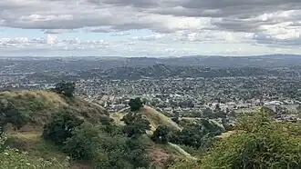 View of the South Hills from the top of Colby Trail | |
| Highest point | |
| Elevation | 370[1] m (1,210 ft) |
| Geography | |
  South Hills location of South Hills in California[1] | |
| Country | United States |
| State | California |
| District | Los Angeles County |
| Range coordinates | 34°7′16″N 117°50′50″W / 34.12111°N 117.84722°W |
| Topo map | USGS San Dimas |
The South Hills are a low mountain range of the Transverse Ranges, within the San Gabriel Valley in eastern Los Angeles County, California.[1] Their elevation ranges from 740 ft at the base to 1212 ft at their highest peak.[2]
The South Hills are north of the Interstate 210 Freeway, in the southern part of the city of Glendora, with the western portion of the hills in the City of Glendora's South Hills Park. They are north of the unincorporated town of Charter Oak and northwest of the city of San Dimas.
References
- ^ a b c "South Hills". Geographic Names Information System. United States Geological Survey, United States Department of the Interior. Retrieved 2009-05-04.
- ^ Swinney, Dick (1994). Glendora Foothills Plant Checklist San Gabriel Mountains. Sun Valley, California: Theodore Payne Foundation. p. 2. ISBN 0-9627781-1-7.
External links
- Park Locations and Facilities, City of Glendora