Giano dell'Umbria
Giano dell'Umbria | |
|---|---|
| Comune di Giano dell'Umbria | |
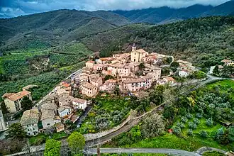 View of Giano dell'Umbria | |
.svg.png) Giano within the Province of Perugia | |
  Giano dell'Umbria Location of Giano dell'Umbria in Italy 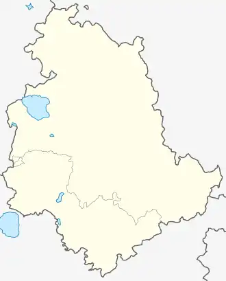 Giano dell'Umbria Giano dell'Umbria (Umbria) | |
| Coordinates: 42°50′01″N 12°34′41″E / 42.833729°N 12.578094°E | |
| Country | Italy |
| Region | Umbria |
| Province | Perugia (PG) |
| Frazioni | Bastardo |
| Government | |
| • Mayor | Marcello Bioli |
| Area | |
• Total | 44.48 km2 (17.17 sq mi) |
| Elevation | 547 m (1,795 ft) |
| Population (1 January 2025)[2] | |
• Total | 3,636 |
| • Density | 81.74/km2 (211.7/sq mi) |
| Demonym | Gianesi |
| Time zone | UTC+1 (CET) |
| • Summer (DST) | UTC+2 (CEST) |
| Postal code | 06030 |
| Dialing code | 0742 |
| Website | Official website |
Giano dell'Umbria is a comune (municipality) in the Province of Perugia in the Italian region Umbria, located about 35 km southeast of Perugia. It is one of I Borghi più belli d'Italia ("The most beautiful villages of Italy").[3]
Etymology
The name of Giano is traditionally derived from a nearby temple dedicated to the god Janus.[4]
History
Before the mid-13th century the area was held by local noble lords, who also possessed nearby castles. In 1247 it was included, together with Castagnola, Montecchio and Macciano, in the territory granted by the Church to Spoleto.[5]
Control remained contested in the later 13th century. Disputes arose in 1274 between ducal authority and the city of Spoleto, followed by renewed submission of the local inhabitants and the reassertion of Spoleto's control in 1279. Further conflicts in 1281 again ended with submission to Spoleto.[5]
The settlement does not appear in the district records of Spoleto in 1361, but was reinstated under its jurisdiction by papal decree on 24 June 1440. This arrangement proved unstable: it was removed from Spoleto's control in 1474 by papal legate Della Rovere, then restored to its jurisdiction in 1478.[5]
In the early 16th century the community, together with nearby settlements, voluntarily submitted to Spoleto. Severio Minervio of Spoleto was granted the lordship of Giano by Pope Leo X in the early 16th century, but the inhabitants refused to accept his authority and instead secured their freedom by paying a substantial sum. In 1527 the castle was left undefended against League forces. It was granted in 1529 to Lorenzo Cybo, but by 1530 had returned to Spoleto's control; Cybo's claims were later renounced, and full rights were transferred to the city after negotiations.[5]
From 1530 until 1816 the territory remained continuously under Spoleto. In 1816 it was recognized as an autonomous administration, and in 1817 established as a municipality under the governor of Montefalco, including Montecchio, Morcicchia, Castagnola and Muriano. The same administrative structure was confirmed in 1827, and by 1833 additional dependent localities included Collemezzo, Fabbri, Macciano, Rustichino, Sagiano, San Savino and Santo Stefano.[5]
By 1858 the municipality formed part of the province of Spoleto and was governed from Montefalco; its dependencies had been reduced to Castagnola and Montecchio.[5] In the mid-19th century Giano had a population of 968 inhabitants. Of these, 145 lived in the town and 823 in the surrounding countryside.[4]
Following the unification of Italy it was included in the region of Umbria. Castagnola and Montecchio remained dependent in 1861. In 1863 the municipality adopted the name Giano dell’Umbria.[5]
Geography
Giano is situated on a hill at the foot of the Monti Martani, with a wide and open outlook extending toward the north. The surrounding territory includes wooded areas with oak and beech.[4] The climate is described as fairly temperate, with prevailing winds from the south and north.[4]
Giano dell'Umbria is situated at an elevation of 547 metres (1,795 ft) above sea level. It lies about 21 kilometres (13 mi) from Spoleto and 10 kilometres (6.2 mi) from Montefalco. The territory is largely hilly.[6]
The municipality includes several frazioni: Collemezzo, Fabri, Macciano, Rustichino, Sagiano, San Savino and San Stefano. It also had dependent localities including Castagnola and Montecchio.[4] The municipality also contains the frazione (subdivision) of Bastardo.
The municipality borders the following municipalities: Castel Ritaldi, Gualdo Cattaneo, Massa Martana, Montefalco and Spoleto.
Religion and culture
The parish church of Giano is dedicated to San Michele Arcangelo. The town's patron saint is San Felice, bishop and martyr, whose feast is celebrated on 30 October.[4]
About 1.25 miles (2.01 km) from the town stands the sanctuary of San Felice, a frequently visited complex consisting of a three-part church and an adjoining convent. The site preserves the remains of the saint, said to have been brought there in the early 4th century. The complex includes structures built by Benedictines, later occupied by Augustinians until the 18th century, and subsequently by Passionists until 1799.[4]
Other religious buildings include the church of the Madonna delle Grazie, of octagonal form, and San Francesco, a Latin cross church with an attached convent, containing an organ and decorated altars.[4]
In 1815 Gaspare del Bufalo established in Giano a mission house dedicated to the Most Precious Blood and to Francis Xavier, which remained active thereafter.[4]
The town is noted for the presence of two castles of ancient and distinctive construction.[6]
Notable people
Giano is the birthplace of the engineer Antonio Rutili Gentili, author of various works and member of the revision of the Censo morto, and of the physician Gioacchino Pompili, noted as a practitioner of homeopathy.[4]
Notable families
Among the principal families recorded in the 19th century are the Pompili, Masci and Santi.[4]
See also
References
- ^ "Superficie di Comuni Province e Regioni italiane al 9 ottobre 2011". Italian National Institute of Statistics. Retrieved 16 March 2019.
- ^ "Resident population by age, sex and marital status on 1st January 2025". Istat. Retrieved 15 February 2026.
- ^ "Umbria" (in Italian). Retrieved 1 August 2023.
- ^ a b c d e f g h i j k Palmieri, Adone (1858). Topografia statistica dello Stato Pontificio. Vol. 5. Tipografia Forense. p. 43-44.
- ^ a b c d e f g "Comune di Giano dell'Umbria". Sistema Informativo Unificato per le Soprintendenze Archivistiche (in Italian). Retrieved 14 February 2026.
- ^ a b Strafforello, Gustavo (1895). La patria; geografia dell'Italia. Provincia di Perugia. Unione Tipografico-Editrice. p. 282.
External links
 Media related to Giano dell'Umbria at Wikimedia Commons