| 2026 United States wildfires |
|---|
|
| Total fires | 5,089[1] |
|---|
| Total area | 85,969 acres (34,790 ha)[1] |
|---|
This is a list of wildfires across the United States during 2026, that have burned more than 1,000 acres (400 hectares), produced significant structural damage or casualties, or otherwise been notable. Acreage and containment figures may not be up to date.
Background
Season background
While most wildfires in the United States occur from May to November, wildfires can occur at any time of the year. Peak fire season typically occurs in August, when temperatures are at their highest and the driest. Wildfires outside of the fire season are becoming more common due to climate change and changing weather patterns. Rising temperatures are leading to earlier snowmelt and later fall and winter precipitation. Drought and hot, dry weather events are becoming more common. Forest pests, such as bark beetles, and invasive species, such as cheatgrass, kill trees and make forests more vulnerable. Areas with dense vegetation or tree cover provide ample fuel for fires.[2]
Seasonal forecasts
In January 2025, the National Interagency Fire Center (NIFC), issued its National Seasonal Fire Outlook. This forecast projected above-normal wildfire risk for much of Texas, Florida, Georgia, Carolinas, and the southeastearn United States. The elevated risk was linked primarily to persistent atmospheric patterns resembling La Niña, which typically reduce precipitation and increase temperatures in these regions. The outlook considered factors such as expected temperature and precipitation anomalies, soil moisture, and vegetation dryness to predict fire activity for the upcoming season.[3]
Climatic conditions
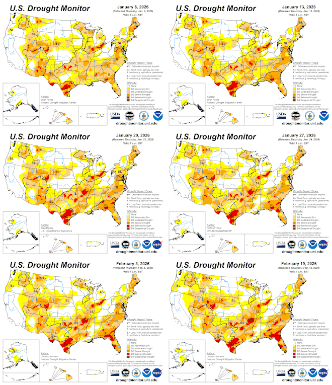
Animation of US drought map 2026
In January 2026, the U.S. Drought Monitor reported that 69% of the United States was under drought conditions, with the South being the hardest-hit region. [4] On January 6, for the first time since 2000, California was drought-free.[5]
Seasonal summary
Firefighting efforts in 2026 required record mobilization of personnel and resources. Incident management teams, ground crews, and aerial firefighting assets were extensively deployed to manage numerous large and complex fires. However, prescribed burning and mechanical fuel reduction strategies faced limitations due to narrow windows of safe weather conditions and ongoing drought, constraining mitigation options during the critical peak season.[6]
[7]
[1]
2026 United States wildfires by month[8]
|
Jan |
Total
|
| Number of Fires
|
2,909 |
2,909
|
| Acres Burned
|
34,965 |
34,965
|
List
Notes
- ^ Containment means that fire crews have established and secured control lines around the fire's perimeter. These lines are artificial barriers, like trenches or cleared vegetation, designed to stop the fire's spread, or natural barriers like rivers. Containment reflects progress in managing the fire but does not necessarily mean the fire is starved of fuel, under control, or put out.[9]
References
- ^ a b c "National Interagency Fire Center National Fire News Year-to-date statistics". National Interagency Fire Center. January 17, 2026. Retrieved January 17, 2026.
- ^ "When is Wildfire Season in the US?". wfca.com. Western Fire Chiefs Association. Retrieved July 9, 2025.
- ^ "Climate Prediction Center". NOAA Climate Prediction Center. Retrieved January 24, 2026.
- ^ "U.S. Drought Monitor". U.S. Drought Monitor. Retrieved January 24, 2025.
- ^ "California completely drought free for the first time in 25 years". The Weather Network. Retrieved January 24, 2026.
- ^ "National Significant Wildland Fire Potential Outlook". National Integrated Drought Information System. February 1, 2026. Retrieved February 13, 2026.
- ^ "Departments of the Interior and Agriculture Announce Wildland Fire Service Plan to Modernize and Support the Wildland Fire Workforce". U.S. Department of the Interior. January 13, 2026. Retrieved February 13, 2026.
- ^ "Wildfires Report 2026". National Centers for Environmental Information.
- ^ "What containment and other wildfire related terms mean". Los Angeles: KCAL-TV. September 12, 2024. Retrieved July 25, 2025.
- ^ "Shell Creek Fire Map". Watch Duty. Retrieved January 16, 2025.
- ^ "Calf Fire Map". Watch Duty. Retrieved January 16, 2025.
- ^ "Silver Lake Fire Map". Watch Duty. Retrieved January 21, 2026.
- ^ "Silver Lake - Wildfire and Smoke Map". data.floridatoday.com. Retrieved February 3, 2026.
- ^ "Havasu Fire Map". Watch Duty. Retrieved January 20, 2025.
- ^ "Havasu Fire Information". InciWeb. Retrieved January 21, 2026.
- ^ "ST-1 Alpha Fire Map". Watch Duty. Retrieved February 3, 2026.
- ^ "Curry Island 26 (22) Fire Map". Watch Duty. Retrieved February 7, 2026.
- ^ "Buggy - Broward (06) Fire Map". Watch Duty. Retrieved February 7, 2026.
- ^ "Leche Fire Map". Watch Duty. Retrieved February 9, 2026.
- ^ "352 Fire Map". Watch Duty. Retrieved February 9, 2026.
- ^ "W Boundary Rd (26) Fire Map". Watch Duty. Retrieved February 11, 2026.
- ^ "640 (53) Fire Map". Watch Duty. Retrieved February 11, 2026.
- ^ "Flat Tire Fire Map". Watch Duty. Retrieved February 11, 2026.
- ^ "Gray Fire Map". Watch Duty. Retrieved February 12, 2026.
- ^ "First Point (22) Fire Map". Watch Duty. Retrieved February 14, 2026.
- ^ "Levy (49) Fire Map". Watch Duty. Retrieved February 15, 2026.
- ^ "County Road 89 Fire Map". Watch Duty. Retrieved February 18, 2026.
- ^ "County Rd 169 Hwy 24 Fire Map". Watch Duty. Retrieved February 17, 2026.
- ^ "Smith Fire Map". Watch Duty. Retrieved February 17, 2026.
- ^ "43 Road Fire Map". Watch Duty. Retrieved February 17, 2026.
- ^ "Side Road Fire Map". Watch Duty. Retrieved February 17, 2026.
- ^ "Ranger Road Fire Map". Watch Duty. Retrieved February 17, 2026.
- ^ "Stevens Fire Map". Watch Duty. Retrieved February 17, 2026.
- ^ "8 Ball Fire Map". Watch Duty. Retrieved February 17, 2026.
- ^ "Lavender Fire Map". Watch Duty. Retrieved February 17, 2026.
|
|---|
| North America | |
|---|
| South America | |
|---|
| Oceania | |
|---|
|